
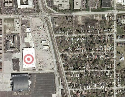
I’m staying at this hotel near Chicago O’hare airport and I go on google maps to scroll around to see what is in the area. I see this giant bullseye on the roof of a building. I stop for a moment, not knowing what it is for… then I realize it is a target logo. Brilliant. Now I know there is a Target store nearby (whether I wanted to or not).
This serves two purposes:
- Online map users can see the store quickly and easily in satellite view
- Airplane passengers see the branding and store location as they’re landing
This is brilliant — a great way to capitalize on satellite imaging for branding.
|
|
See for yourself on google maps: Example 1 - Chicago IL Example 2 - Everett MA (thanks Colonel Kernel) |
and here’s the link to Target’s store in Everett, MA, also via Google Maps –
http://maps.google.com/maps?f=q&hl=en&geocode=&q=Everett,+Middlesex,+Massachusetts,+United+States&ie=UTF8&ll=42.398377,-71.072338&spn=0.011076,0.027122&t=h&z=16
and I agree, this is brilliant, until some looney decides to bomb the stores, then not so much
It appears this is something Target is doing near all major airports from some other blogs I’ve read. I just started researching it because I saw a giant (250 foot) bullseye on the roof of the Target store at Potomac Yards (Alexandria, VA) right next to National (no I won’t call it Reagan-National) Airport
I was just flying from Memphis to PVD and stopped in Atlanta. I saw the same thing on a top of a Target when Landing in Atlanta.
http://maps.google.com/maps?f=q&source=s_q&hl=en&q=Target&sll=33.658969,-84.4988&sspn=0.006144,0.009602&ie=UTF8&t=h&rq=1&ev=zi&radius=0.33&split=1&hq=Target&hnear=&ll=33.658969,-84.4988&spn=0.006144,0.009602&z=17
San Antonio, too.